Earthquake May Have Set Off Glacier Collapse Behind Nepal’s Devastating Flash Floods: ISRO
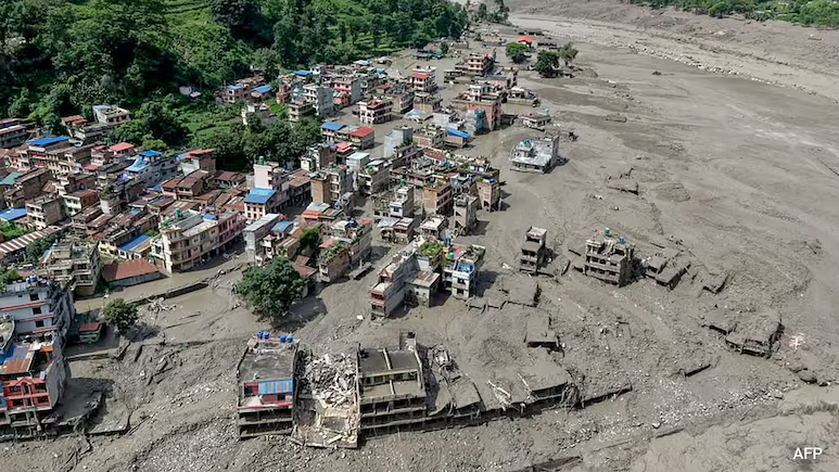
Rasuwa, Nepal : A powerful chain of natural events may have been behind the devastating flash floods that struck Nepal’s Rasuwa region, according to a preliminary satellite-based assessment by scientists associated with India’s space programme.
India’s National Remote Sensing Centre (NRSC), a key organisation under the Indian Space Research Organisation (ISRO), has been studying satellite images of the affected region to understand how the disaster unfolded. The initial findings suggest that a magnitude 4.9 earthquake may have triggered the collapse of a cirque glacier, setting off an enormous avalanche of ice and rocks.
The disaster then appears to have developed into a deadly chain reaction. The avalanche may have blocked a river channel for a short period, allowing water to accumulate. When that natural barrier eventually gave way, a huge surge of water, mud, rocks and debris rushed downstream, flooding areas along Nepal’s Trishuli river system.
Earthquake Recorded in the Rasuwa Region
According to the preliminary assessment, India’s earthquake monitoring network detected a magnitude 4.9 earthquake at around 8:22 am IST. The earthquake was recorded at a depth of approximately 10 kilometres, with its reported coordinates corresponding to the Rasuwa region.
The Himalayan belt is one of the world’s most earthquake-prone regions, and even moderate seismic activity can destabilise already fragile mountain slopes, glaciers and rock formations.
Scientists are still examining the exact relationship between the earthquake and the glacier collapse. The use of the word “may” is important because the findings are preliminary and further investigation is required to establish the precise trigger.
Satellite Images Help Reconstruct the Disaster
With roads and mountain terrain severely affected by the floods, satellite technology has provided scientists with an important way to examine the damage.
NRSC scientists in Hyderabad compared satellite images taken before and after the disaster. They examined imagery from the European Sentinel-2 satellite, captured on August 24, and compared it with imagery from ISRO’s Resourcesat-2A, captured on August 26.
An earlier Resourcesat-2A image from April 4 was also studied to identify changes in the landscape.
The comparison revealed major changes along the river corridor, including extensive debris deposits and areas affected by flooding. Such satellite-based assessments allow scientists and disaster-response agencies to identify damaged zones even when ground teams cannot easily reach remote mountainous locations.
How a Glacier Collapse Could Have Turned Into a Flash Flood
At the centre of the preliminary investigation is the collapse of a cirque glacier.
A cirque glacier develops in a bowl-shaped depression on a mountain where snow and ice accumulate over time. These areas can become unstable because of geological activity, avalanches, changing temperatures or other environmental factors.
According to the preliminary assessment, the possible sequence began with the glacier collapsing and sending a massive mixture of ice and rocks down a steep mountain valley.
The avalanche may then have temporarily blocked a river. Water built up behind the blockage, creating a natural reservoir. Once the barrier failed, the accumulated water was suddenly released, carrying enormous quantities of mud, rocks and debris downstream.
This could explain how a mountain event developed into a rapidly moving flash flood capable of causing widespread destruction.
Rasuwa Bears the Brunt of the Disaster
The Rasuwa region has witnessed severe destruction as floodwaters and debris moved through the mountainous landscape. Villages, roads and other infrastructure have been damaged, while rescue teams continue to deal with the aftermath.
The event highlights the particular vulnerability of Himalayan communities. Steep slopes, glaciers, rivers and active seismic zones exist within a relatively compact area, meaning one natural event can trigger another.
An earthquake can destabilise a slope, a landslide can block a river, and the eventual collapse of that blockage can create a destructive flood wave. These cascading hazards make disasters in high-altitude regions especially difficult to predict.
Why the Findings Matter
The NRSC assessment also demonstrates how space technology is increasingly becoming an important part of disaster management.
Satellite imagery can help authorities quickly identify flood-affected areas, map changes in rivers and terrain, locate large debris deposits and assess damage to infrastructure. This information can support rescue operations and help authorities identify areas that may face further risks.
Scientists can also use repeated satellite observations to monitor whether unstable slopes or altered river channels continue to pose a threat after the initial disaster.
A Wider Warning for the Himalayas
The Nepal disaster is another reminder of the complex risks facing the Himalayan region. Earthquakes, glacier instability, landslides and flash floods can interact with one another, creating disasters that are far more destructive than any single event alone.
While the preliminary assessment points to a possible earthquake-triggered glacier collapse, scientists will need more evidence before the complete chain of events can be confirmed.
For now, satellite observations are helping piece together what happened in the mountains of Tibet and Nepal and how a possible glacier collapse developed into a devastating flash flood.
As rescue and recovery efforts continue in Rasuwa, Nepal, continued monitoring of the region will be crucial—not only to understand this disaster but also to identify and respond to potential secondary hazards in the fragile Himalayan landscape.
News source: Information for this article was gathered from a variety of reliable news outlets